Keyport Complete Streets Policy and Implementation Plan
 The Borough of Keyport sought assistance in developing a Complete Streets Policy and Implementation Plan. Complete streets are roads designed for users of all ability levels and all travel modes. They balance the needs of pedestrians, bicyclists, drivers, transit riders, emergency responders and goods movement. This study created a complete streets ordinance, which upon adoption would amend Keyport's municipal code to prioritizing implementing complete streets in all design, planning, construction and maintenance projects.
This study also resulted in the creation of a  Complete Streets Design Guide and Complete Streets Implementation Guide. The Design Guide, created with extensive community engagement, identifies priority locations and design recommendations for different types of streets — such as main roads, neighborhood connectors and downtown commercial corridors. The guide identifies priority pedestrian and bicycle networks and areas to improve green stormwater management. It seeks to help advance the Borough’s sustainable land use, transportation, economic, and green building planning elements.
The Implementation Guide supports the complete streets ordinance and the Design Guide. It presents best practices for implementing complete streets projects and encourages community involvement. The Implementation Guide provides criteria for prioritizing projects and identifies potential funding sources.
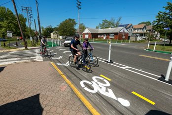
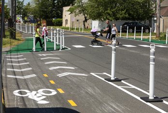
As part of this effort the Borough constructed a temporary demonstration project, also called a quick build, to show community members what potential improvements to the intersection of Maple Place, Atlantic Street and Church Street could look like. The project aimed to calm traffic and increase motorist visibility of pedestrians and bicyclists at the intersection and create safe access to the nearby Henry Hudson Trail. The project included installation of a temporary bike lane and crosswalk.
Planning for Emerging Centers Program Overview:
The Planning for Emerging Centers Program, managed by the NJTPA, provides technical assistance to municipalities for the development of local policies, regulations and planning activities that promote transit-supportive and pedestrian-oriented development and redevelopment. The goal of the program is to advance local sustainable transportation and land use planning that benefits the region’s economy, environment, and quality of life.
Local studies supported under the program will involve robust participation from stakeholders and the public, as well as implementing agencies at the municipal, regional, and state level (such as the NJ Department of Transportation, NJ TRANSIT, Transportation Management Associations, and counties). Recommendations produced from these studies shall be consistent with the NJTPA Regional Transportation Plan (RTP) and advance actions identified by the Together North Jersey (TNJ) Plan.
The Planning for Emerging Centers Program will address increased demand for diverse, mixed‐use development that supports transit, bicycling and walking as well as implement the strategies and actions developed through the TNJ planning process. The NJTPA Planning for Emerging Centers Program works cooperatively with and advances the goals of the Transit Friendly Program administered by NJ TRANSIT and the NJDOT Transit Village Program.