Technology - ITS
 The term “Intelligent Transportation Systems” refers to the use of information and communications technology to improve transportation safety, efficiency, and system performance. The organization “ITS America” provides these examples of ITS:
Advanced Traveler Information Systems deliver data directly to travelers, empowering them to make better choices about alternate routes or modes of transportation. When archived, this historical data provides transportation planners with accurate travel pattern information, optimizing the transportation planning process.
Advanced Traffic Management Systems employ a variety of relatively inexpensive detectors, cameras, and communication systems to monitor traffic, optimize signal timings on major arterials, and control the flow of traffic.
Incident Management Systems, for their part, provide traffic operators with the tools to allow quick and efficient response to accidents, hazardous spills, and other emergencies. Redundant communications systems link data collection points, transportation operations centers, and travel information portals into an integrated network that can be operated efficiently and “intelligently.”
The NJTPA sponsors periodic workshops on the application of various technologies, offering public sector and private partners a chance to exchange their experience and expertise.
The NJTPA is a participant and stakeholder in a state-level project led by NJDOT to maintain and update the New Jersey Statewide ITS Architecture. The updated architecture document and resources are at the project website.
The New Jersey Statewide ITS Architecture has been updated to conform with the requirements of FHWA and FTA. This includes identifying current and planned ITS projects in New Jersey and updating the Architecture with the latest version of the National ITS Architecture v8.3, called the Architecture Reference for Cooperative and Intelligent Transportation (ARC-IT). Read More
 CV & AV
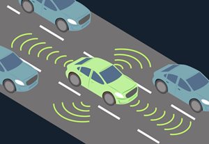
- Connected Vehicles use short to medium range communications to interface with infrastructure and other vehicles allowing coordination of movements to minimize crashes, reduce congestion and make more efficient use of road space, among other applications. The technology can be extended to communicate with pedestrians, bicyclists and other modes, and possibly buildings and non-transportation systems. This direct communication allows drivers to make better decisions. Examples of connected vehicle applications include warnings to drivers who are on a trajectory to crash, running a red light, a sharp curve ahead, a work zone, or of stopped traffic ahead. Technology can also provide drivers with advice on when it is safe to pass, change lanes, make left turns across traffic, or proceed after stopping at a stop sign.
- Fully Automatous Vehicles could have a drastic impact on communities in the NJTPA region, not only on mobility, but on land-use, municipal revenue, parking requirements, and use of downtown curb-space. Automated vehicles use sensors and computers to provide varying levels of driving functionality, from assistance to drivers to full driver-less operation. While the impact may be great, the future of AV development and deployment remains unclear. NJTPA hosts conversations and forums with industry leaders to appropriately stay abreast of developments and incorporate the risks and promise of automatous vehicles in our planning initiatives.
Traffic Signals
- Traffic signal operational upgrades can improve safety and air quality, as well as reduce congestion. NJTPA funds numerous traffic signal upgrades throughout the region through various programs, including Transportation Clean Air Measures and the Local Safety Program. Traffic Signals are controlled by computers and often use sensors to detect traffic to improve road operation and reduce driver delays. Signals are often coordinated along a corridor. Traffic Engineers conduct analysis to provide for optimized traffic signal timings for various times throughout the day. However, as traffic patterns change over time, signal timings can become out of date. Some systems provide alerts to engineers when signal timings are not effective, while more advanced technologies (Adaptive) allow for signals to re-time themselves continually to remain optimized.
- Transporation Systems Managment and Operations (TSMO) uses technology and staffing to more effectively operate and manage the multimodal transportation system. Strategies in the NJTAP region include traffic management centers (such as the NJ Statewide Traffic Management Center), deployments of sensors along roadways, and Dynamic Messaging Signs (DMS). Operators in the traffic management centers receive information about conditions and problems though sensors which can be conveyed in real-time to drivers though the DMS, 511 and/or navigation applications. They can also dispatch resources, including police and tow. This reduces impacts of crashes and incidents and reduces secondary crashes.
 Driver Information
- Technology and marketplace advancements continue to change the way drivers receive traveler information to support their decision making. There has been a near-universal adoption of mobile applications (Waze, Google Maps, & Apple Maps) for navigation, supported by the phone-vehicle integration of Apple and Android CarPlay. Drivers now receive and provide real-time roadway information, which allows for real-time re-routing around congestion and incidents as it happens, both saving the individual driver time, and better utilizing the overall system capacity in a balanced way. The dynamic nature of mobile app routing can present challenges for local communities such as when local roadways are burdened by a higher volume of traffic re-routed by the apps.
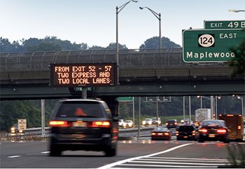
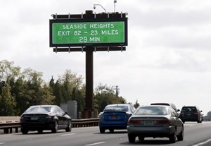
- Dynamic Messaging Signs (DMS) are large digital signs on roadways which can provide various messages to drivers on the roadway. These signs are primarily used for real-time information (including crashes, construction, and delays), but also can display travel times and safety messages.
 Technology as access to mobility
- Transportation Network Companies (such as Uber and Lyft), provide services that are an alternative to taxis, accessed through cell-phone based applications. The apps serve as a marketplace which connects drivers to riders who are charged based on mileage and trip time. One advantage of TNCs is that they can easily provide trips across municipal lines since they are regulated at a state-level. Specific products can vary, including a higher rate for a larger or more premium vehicle, or a lower rate for a longer wait or shared rides with other riders. Through public-private partnerships, TNCs have provided rides after natural disasters (including Ida), and during major transit disruptions.
- As an alternative to car ownership, car sharing allows multiple people in a community to share the use of fewer vehicles. Personal vehicles spend most of their time parked as an underutilized asset to their owner. Similar to the AirBNB business model, there are app-enabled peer-to-peer car sharing where individuals can rent out their vehicles when they are otherwise not being used (e.g., Turo). Additionally, private companies offer subscription-based car sharing (including ZipCar, Enterprise CarShare, GetAround, Maven, etc.). In some cases, Municipalities can incentivize the use of car sharing, such as Hoboken’s Corner Car program, which provides reserved on-street parking spots for car share, and in return provide an expanded mobility option to residents.
- Micro-transit provides a door-to-door ride service in a shared vehicle. It is a cost-effective method to expand mobility in areas which are underserved and may not have sufficient demand for traditional fixed-route public transit. Jersey City operates a micro-mobility system focused on expanding mobility options in areas of the city under-served by fixed-route transit. Their program (in partnership with, and co-branded with Via), allows for riders to hail or schedule a door-to-door ride for a low, subsidized fare. Like public transit, the ride vehicle may make multiple stops, and be shared with other riders.
Top and middle photos: Ed Murray; bottom photo: Diego - stock.adobe.com