

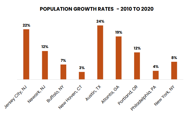
Jersey City has been among the fastest-growing cities not only in New Jersey but the nation over the past decade with population growth rivaling Austin, Texas, and outpacing Atlanta, Georgia; Portland, Oregon, and even its neighbor across the Hudson, New York City. That means more people walking, biking, driving, and taking transit in the second-largest city within the most-densely populated county in New Jersey. How the city and county are accommodating transportation needs was the topic of a presentation to the Regional Transportation Advisory Committee (RTAC) at its February 9 meeting.
Elias Guseman, Senior Transportation Planner, Jersey City Division of Transportation Planning, and Kevin Force, Supervising Planner, Division of Planning, Hudson County, presented “Transportation Impacts of Jersey City’s Growth on the City and Hudson County.”
 Since adoption of the last master plan in 2011, Jersey City has grown by 22 percent and is projected to grow another 25 percent by 2050. While downtown has seen significant growth in the recent building boom, other neighborhoods like West Side, Journal Square, and Bergen-Lafayette are expected to drive future growth, according to Guseman. The current master plan, “Let’s Move JC,” is developing targeted transportation plans for those neighborhoods to address “short-term transportation challenges while identifying long-term solutions to make sure neighborhoods grow in a way that both supports current residents and their future neighbors,” he said.
“We’re looking at everything from transit, curb management, loading zones, bike lanes, and pedestrian safety to make sure all trips are safe accessible and convenient.”
About half of all trips in Jersey City are made by car and driving has increased roughly 12 percent compared to pre-pandemic levels, according to Guseman. Walking has remained at about 25 percent of trips. Transit is about 20 percent of trips, with ridership rebounding after a post-pandemic decline. Biking comprises a relatively small share of total trips but has tripled since 2019 along with bicycle infrastructure investments over that same period, he said.
Since 2019, the city has installed:
- 760+ speed bumps
- 725+ No Right Turn on Red restrictions
- 45+ Rectangular Rapid Flashing Beacons
- 300+ intersections with new curb extensions
- 33 Leading Pedestrian Intervals (LPIs), and another 15 planned this year
- 24+ miles of protected bike lanes
Major projects completed last year to advance safety included bike lanes to connect the Journal Square Transportation Center and traffic-calming measures along Monticello Avenue after a successful demonstration project through the NJTPA’s Subregional Studies Program (SSP).
 In response to growth in Jersey City and other areas of Hudson County, including transit-oriented development in Harrison and Bayonne, the county has taken a multi-pronged approach, according to Force. Roadway projects have included concept and design work along Paterson Plank Road, which connects Jersey City with Hoboken and cities to the west, a bike lane on Duncan Avenue that will connect to the city’s bicycle network, and traffic calming and lighting improvements along other roadways.
Through the SSP, the county has completed a Hudson County Ferry Study and the West Hudson Circulation and Connectivity Study, focused on Harrison, Kearny, and East Newark, which yielded public interest in better connectivity to other municipalities, especially Jersey City. The county also will conduct a Bus Rapid Transit/Bus Prioritization Study for JFK Boulevard.
Hudson County has advocated that NJ Transit acquire discontinued Coach USA bus routes, increased PATH service, and the extension of the Hudson-Bergen Light Rail over Route 440. Other planning initiatives include the Hackensack River Greenway Plan and the Hudson County Vision Zero Action Plan.
A recording of the RTAC meeting and related materials can be found here.